Charting the Coast
With each new method, surveyors find new secrets
Back in the fall of 1866, a 117-foot-long steamboat was stationed off Metinic Island at the mouth of Penobscot Bay from September 6 to November 1. Each day the vessel moved back and forth very, very slowly as a crew took hundreds of soundings, a total of 7,500 over the eight weeks.
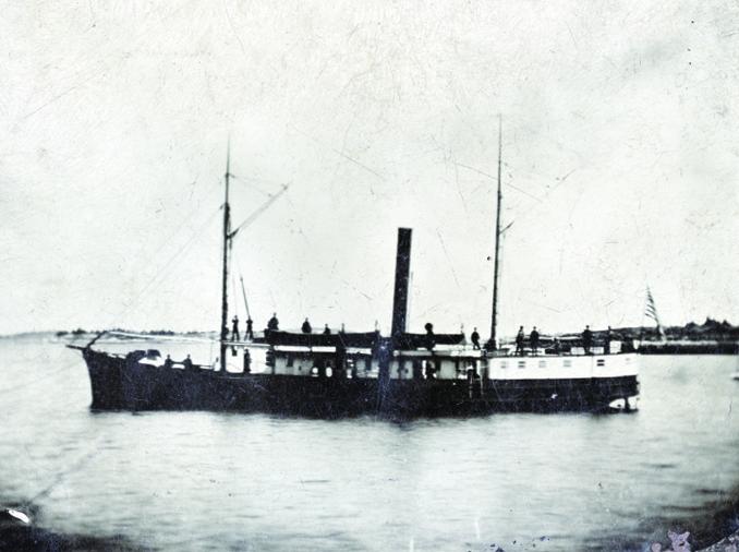 The steamship Endeavor was built in Norfolk, Virginia, for the Confederate Navy in 1862. She was captured and used by the Union for a few years before being turned over to the Coastal Survey, along with two other former Navy boats. According to NOAA records, she was used for hydrographic surveys along the Eastern seaboard until the 1880s. This tintype was taken in Penobscot Bay. Courtesy Penobscot Marine Museum
That vessel, Endeavor, a former blockade-runner captured from the Confederate Navy during the Civil War, was part of the first official fleet to provide data for detailed nautical charts of the Maine coast.
Last summer, 150 years later, another team of hydrographers returned to the bay. But instead of hand-held lead-lines and sextants, they used sophisticated equipment that can collect almost as much data in a second as the Endeavor’s crew collected in an entire summer.
Back in 1866, the laborious process of measuring depths involved hand-casting lines fixed with lead weights at regular intervals, usually 200 feet or more, measuring the distance to the bottom, and then determining position by triangulating sextant fixes from land-based points. Charting even just a small area took days, and since the lead casts were limited, it was easy to miss rocks. It took the crew of Endeavor another five years to complete the hydrographic survey of Penobscot Bay, according to Office of Coast Survey records.
Over the ensuing decades, hydrographic teams returned to the coast of Maine many more times to update charts in select locations. Their methods evolved from the hand-cast lead lines to wire draggers in the early 1900s. This involved towing a long, weighted wire at a specific depth between two vessels. When the wire snagged on something, that spot could be marked and investigated further.
Surveyors using a wire could find things missed by hand-cast soundings.
For example, a 1908 account by G.R. Putnam describes the discovery of a rock in Blue Hill Bay. “This rock has but 7 feet of water over it, and is only 6 feet in diameter at the top. It is surrounded by depths of 78 feet, from which it rises,” he wrote. “The original survey gave no indication of a danger here, and its existence was not suspected until it was discovered with the wire drag.”
Single-beam echo sounders were introduced in the 1930s. These used a single narrow beam (like a flashlight’s) of sound, to measure the distance to the sea floor directly below a vessel. Like previous methods, though, this still left gaps between survey lines.
Last summer, a team employed by the Office of Coast Survey returned to measure depths in Penobscot Bay; the first comprehensive survey since the 1950s. And they had the benefit of incredibly advanced technology. This crew used multibeam echo sounders and computers capable of crunching huge amounts of data to create detailed, color-coded maps of the bay’s hydrography. Gradually this method is being used to resurvey the state’s entire coast.
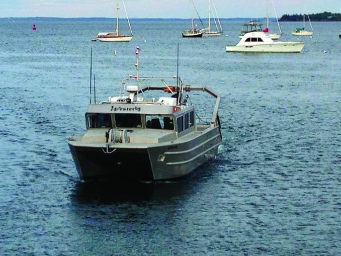 Built by Armstrong Marine in Seattle, this 44-foot aluminum catamaran is one of two that spent the summer of 2016 surveying the bottom of Penobscot Bay. A jetboat, it only draws 2 feet and was able to avoid entanglements with the many lobster buoys along the bay. Courtesy Dean Moyles/Fugro
Two 44-foot jet-propelled aluminum catamarans drove back and forth, day after day, in designated areas, thoroughly documenting the seafloor in a pattern similar to that made by a person mowing a lawn. Each boat’s sonar setup is about three feet wide and hangs about three feet below the water’s surface, explained Dean Moyles, project manager and senior hydrographer with Fugro, the company contracted to do the survey. Each sonar produces 1,024 beams per ping, and pings as many as 10 to 25 times a second (depending on the water depth), he explained. This is essentially the equivalent of making tens of thousands of old-fashioned lead-line soundings in just seconds.
The distance to the bottom is determined by the time it takes each sound pulse to travel down to the seafloor and back to the sonar. Key to ensuring the measurements are accurate is taking regular sound speed profiles. This is because sound travels at different speeds through the water column depending on variables such as temperature and density. The differences in sound speed are monitored constantly, Moyles said.
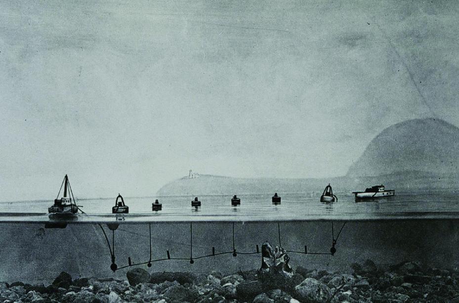 This image shows how the wire drags worked. Basically, two vessels moving parallel towed a wire connected to surface buoys. When the wire hit an obstruction the buoys formed a “v.” Courtesy NOAA
Depending on the water depth, one boat can cover from as little as 3 to 5 square kilometers in shallow water in a day to as many as 20 square kilometers of deep water, Moyles said; they cover more ground in deep water because the sonar swath gets wider as water depth increases.
Sometimes the crew had to conduct re-runs if the sonar was confused by obstructions such as fish. “It detects air in the fish’s bladders,” Moyles said. “We had to survey a block in Tenants Harbor twice because there were so many fish in the water column.”
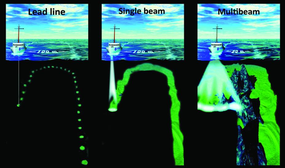 The multibeam sonar, far right, covers much more ground, compared to the single beam sonar, center, and the lead line, left. Courtesy NOAA
In addition to the boat-based surveying, Fugro also flew over the area in a small plane fitted with a LiDAR bathymetry system, which essentially uses laser pulses to determine water depths and shoreline elevations. The airborne survey allowed the crew to determine the depth of some submerged features and plot a safe and efficient route for the survey vessels.
While NOAA has its own fleet of four large hydrography vessels, including the Ferdinand R Hassler, a state-of-the-art 124' multihull based in New Castle, New Hampshire, the work last summer was contracted out to Fugro, a large West Coast-based firm. The Fugro team began July 20 and by the time they left on September 30, they had surveyed about 108 square nautical miles, from Spaulding Island to Mosquito Island, Rockland Harbor, and North Haven to Vinalhaven Island. Their next job was to survey around the base of wind turbines off Rhode Island to map erosion and sediment movement on the ocean floor, Moyles said.
During any nautical survey, substantial changes that present a potential hazard to mariners are submitted right away to NOAA, which can then provide the information to the U.S. Coast Guard for a Notice to Mariners. NOAA also updates its charts within a week. During their time in Penobscot Bay, Moyles and his team submitted data on more than 25 potential dangers to navigation, including uncharted rocks, or rocks that were incompletely marked. For example, they found that McIntosh Ledge, east of Robinson Rock in West Penobscot Bay, actually extends farther southwest than current charts show. In Lawry’s Narrows off Vinalhaven, they found that a shoal marked as being 15 feet down on current charts was actually only 7 feet down at low tide.
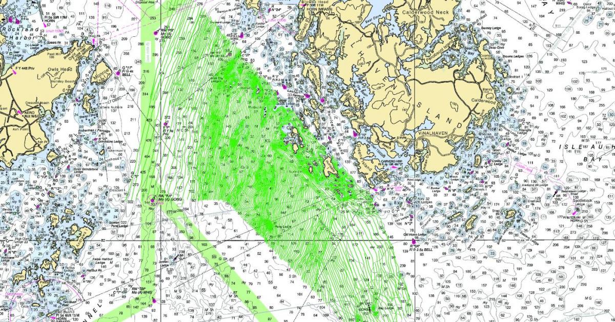 The lines conducted by the survey boats in Penobscot Bay look like a lawn just after it has been mowed. The beams cover less area in shallow water, which means the shallower the water the closer the lines are together. Courtesy Fugro
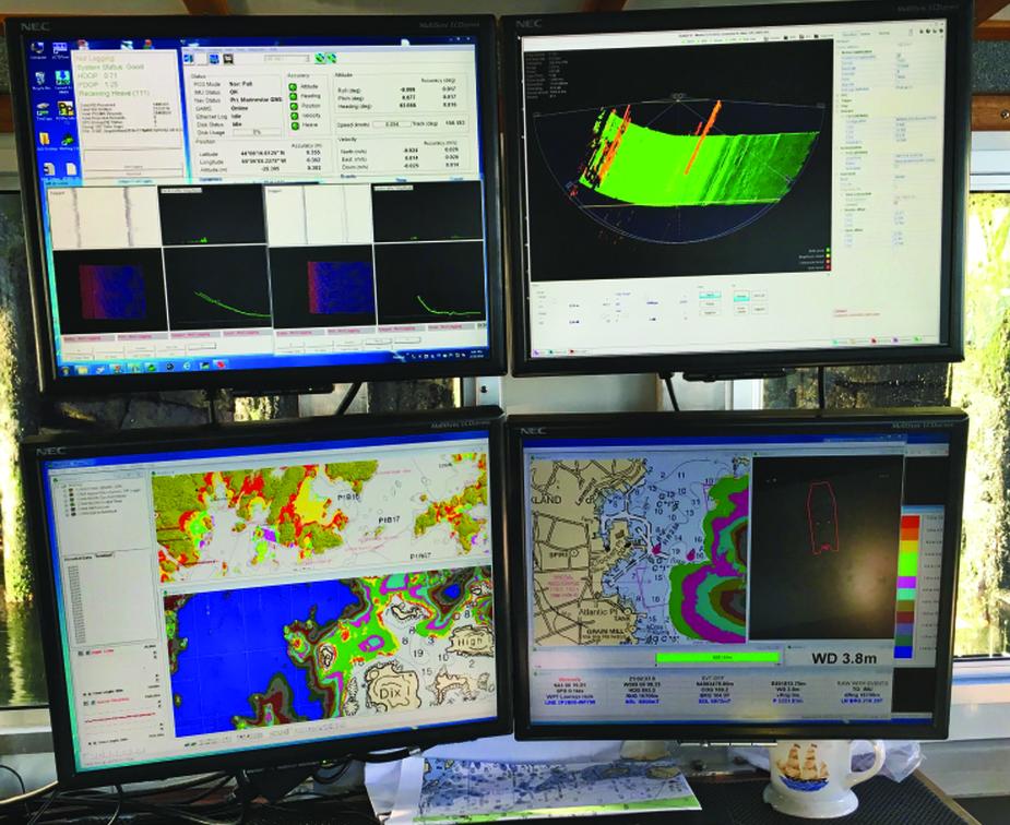 Computers on board the survey boats display the wide range of information being collected. The colors on the screen correspond with depths. The screen on the top right is a side view of the sound beams. Photo by Polly Saltonstall
All the information collected on the water was reviewed on shore and then uploaded to a massive computer server and transferred to Fugro’s office in San Diego, where it will be interpreted and processed. Once the data has been submitted to NOAA’s Office of Coast Survey, that agency decides how to present it on charts. Dean said his boats collect far more information than what the average mariner ends up seeing on a chart. The full resolution data set is in the public domain, however, and will be available for downloading.
The Office of Coast Survey stopped printing paper charts in 2013, in part because of the high cost of printing, but also because the new system of printing charts on demand allows NOAA to make sure its charts contain the most up-to-date information. Back in the days of printed charts, it might take anywhere from three to ten years for new survey information to be included on a new chart, said Office of Coast Survey spokeswoman Dawn Forsythe. Today, the process takes much less time. The data collected by Fugro last summer will be included on new charts within six months, she said.
In addition to the charge to survey a general swath of coastline, the Fugro crew was given a list of reports of specific navigational issues to investigate. At the top of that list was to determine whether a wreck shown on charts of Rockland Harbor really existed, Moyles said. This was important because the alleged wreck was inside the breakwater near the Owls Head shore in an area considered ideal as an anchorage for large vessels such as cruise ships or visiting Navy boats. The Fugro crew quickly determined that the wreck either no longer existed or never did, which meant the site could be, and was, used by a number of visiting vessels over the summer.
Previous surveys along the coast have been done by NOAA’s own vessels. During the winter of 2015, a crew on the Hassler surveyed off Saco, Portland, Kennebunk, and Cape Elizabeth down to Wells—some areas where charts had not been updated for 80 years. Among that crew’s discovery was a shoal about nine feet deep just off Old Orchard Beach.
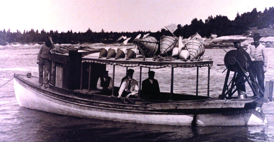 This crew on the 32-foot launch the Adelaide from Rockland, Maine, was conducting a wire drag survey in Penobscot Bay in 1906. Back then the Navy tested new vessels on the bay. On one occasion, a surveying party looking for a reported shoal in the path of the Rockland ship-trial course had just postponed the search because of the presence of so many lobster pots, according to an account by one of the crew. They were returning to port when the drag caught on a rock 22 feet deep. The rock was charted but no buoy was placed. A few years later, the battleship Arkansas hit that rock en route to a trial, which caused $80,000 worth of damage. It turned out the pilot on board was using an old chart. Photo Courtesy NOAA
Back in 1866, while the crew of Endeavor worked at the mouth of Penobscot Bay, other crews were doing similar work up and down the coast. An informal tally based on the Office of Coast Survey report for that year indicates a total of 91,000 soundings taken along the Maine shoreline.
As the 1866 report makes clear, the water-based surveying was the last step in a long process. Before the hydrographers could even begin to do their work, surveyors on land had to establish sites for triangulation. That process took years.
Surveying coastal waters dates back to an 1807 order from President Thomas Jefferson. After several years under the control of the War Department, in 1832 the effort was put under the control of the newly created civilian U.S. Coast Survey (part of NOAA since 1970), which has been the nation’s official nautical chartmaker ever since. It’s an ongoing job because the ocean bottom can be changed by storms and other disturbances, and because improvements in technology have made more detailed surveys possible.
The agency has attracted some of the best and brightest scientists and naturalists over the years, hiring naturalist Louis Agassiz to conduct the first scientific study of the Florida reef system, and the artist James McNeill Whistler as an engraver. The naturalist and conservationist John Muir was a guide and artist on “Survey of the 39th Parallel” across the Great Basin of Nevada and Utah.
 A crew member checks the multibeam echo sounder used for the 2016 survey in Penobscot Bay. It is lowered into the water when in use and raised up when not. Photo by Polly Saltonstall
Today, hydrographic surveys are generally conducted in response to requests by marine pilots, port authorities, the U.S. Coast Guard, fishermen, and the general boating community. For example, a team was sent to Cobscook Bay off Eastport in 2010 in response to a request from local leaders and Maine’s congressional delegation, who were concerned about the loss of 16 fishermen in five years as a result of boats that sank in the bay. The survey team, covering an area that had not been charted for a century, created a new chart with much more detail about rock outcroppings that may have snagged fishing equipment and caused boats to founder.
 Once survey data had been acquired on the water, Fugro project manager Dean Moyles (above) and lead hydrographer Dale Reynolds reviewed it in a shore-side office before transmitting the massive files of information to the company’s office in San Diego. Photo by Polly Saltonstall
The Office of Coast Survey is gradually redoing all of its hydrographic surveys in Maine and elsewhere using the multibeam echo sounder.
Work scheduled for 2017 has not yet been finalized.
Just as in the late 1860s, when surveyors complained their progress was impeded by budget cuts, the work today is limited by the availability of ships and personnel, Forsythe said.
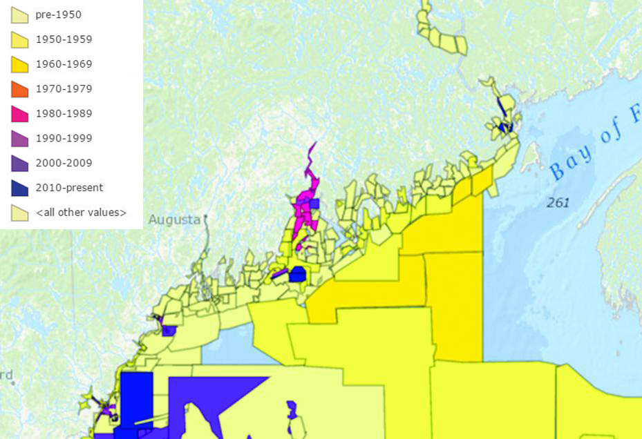 As this chart provided by NOAA shows, much of the Maine coastline was last surveyed in the 1950s or earlier. The Office of Coast Survey is gradually remapping coastal waters using updated technology. Courtesy NOAA
Some boaters these days may feel they don’t need nautical charts because they have GPS screens with electronic chart plotters. They may not realize that the image on the screen comes from an electronic NOAA chart. The GPS will tell you where you are, but the depths shown may be out of date or wrong if the area has not been surveyed recently, or if the charts have not been updated.
So the next time you see a hydrographic survey boat go by, wave and say thanks. They are revealing the secrets of the ocean bottom.
Polly Saltonstall is editor of this magazine.
Related Articles
Share this article:
2023 Maine Boat & Home Show

Join Us for the Maine Boat & Home Show!
Art, Artisans, Food, Fun & Boats, Boats, Boats
August 11 - 13, 2023 | On the waterfront, Rockland, Maine
Click here to pre-order your tickets.
Show is produced by Maine Boats, Homes & Harbors magazine.


